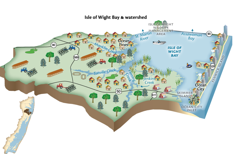
General Description
Isle of Wight Bay’s drainage includes both Worcester and Sussex counties, with nearly 15% of the drainage in Delaware. It is the second largest bay and drainage of the five coastal bays, and includes Manklin Creek, Herring Creek, Turville Creek, St. Martin River, Bishopville Prong, and Shingle Landing Prong. The community of Ocean Pines, the southern half of Ocean City and west Ocean City drain to this bay. The bay is bounded to the north by Route 90 and Route 50 crosses the Bay near its southern boundary.
Ecosystem Health Ranking
- Ranks 3 out of 5
- 2021 Maryland Coastal Bays Report Card
Challenges
The Isle of Wight watershed contains extensive urban development both in Delaware and in Maryland. Impervious surfaces (pavement, rooftop and compacted soils) degrade stormwater quality and impact water quality in the bay. The watershed also contains nearly half of the septic systems in the entire Maryland coastal bays watershed, which contribute to nutrient pollution.
59 of 111 dead end canals in the entire watershed are in the Isle of Wight watershed. Dead-end canals are problematic for several reasons:
- They usually only have one opening
- Most were dug through wetlands which causes canal water to stagnate and become depleted of dissolved oxygen (essential for organisms to survive)
- The canals receive pollutants from stormwater runoff
- Poor flushing
- Excessive nutrients and algae
- Fish kills
- Trash accumulation
- Poor habitat for fish and crabs
- Watercraft pollution
Most canals are stabilized with bulkheading (vertical walls at the interface of shoreline and water). Scouring can undermine the bulkhead and exacerbate erosion. Furthermore, bulkheading was historically made with treated lumber containing toxic chemicals, including copper, chromium, and arsenic. A study of Maryland and Delaware bays found that some bay sediments were contaminated with metals, pesticides, and other chemicals. The most severe contamination was found in areas with boating activity (such as marinas, where boat paints and sacrificial anodes on boats and crab pots are sources of pollution) and intense urbanization (bulkheads, auto-part wear, stormwater runoff, and atmospheric inputs). Although ecological conditions within the canals are degraded, they effectively function as an unintentional best management practice by preventing the release of pollutants into the Coastal Bays themselves. Accordingly, correcting problems within the canals could require the tradeoff that these materials would be exported into the bays.
The Isle of Wight shorelines generally have been extensively altered with bulkheading and rip rap due to residential development. Even when not associated with dead end canals, hardened shorelines that replace natural shoreline reduce water quality and remove and damage habitat, resulting in reduced submerged aquatic vegetation (SAV) and decreased abundance of fish and crabs.
Sea level rise is eroding tidal wetlands and shorelines in all of the coastal bays, leading to problems with flooding in waterfront communities.
Agricultural activities such as tillage and the application of manure/poultry litter/chemical fertilizer/pesticides can contribute pollution to our waterways, and in Isle of Wight Bay watershed it is a large contributor of nutrient pollution. There are over two dozen poultry operations and over 10,000 acres in crop production in the watershed.
Key Current Solutions
Pre-treatment technologies treat wastewater before it reaches the drainfield of septic systems. The state’s Bay Restoration Fund provides grants to either connect septic systems to public sewer or install nitrogen-removing pre-treatment to an existing system, cutting its nitrogen contributions to groundwater in half.
Stormwater management enhancement both improves water quality and addresses flooding. Ocean Pines Homeowner’s Association, in cooperation with Maryland Coastal Bays Program and Worcester County have been exploring ways to enhance stormwater management.
Bishopville fish passageway—completed in 2014—removed a dam which prevented fish such as alewife and blueback herring to reach spawning areas.
Showell Property restoration projects have improved habitat and reduced nutrient pollution.
Lizard Hill Wetland Restoration is a remediated sand mine. The restoration has resulted in improved habitat and water quality
Shoreline restoration where rip rap was removed and replaced with a sill and restored marsh, enhance habitat and reduce nutrient impact. The shoreline restoration at Gum Point Road is an example of this.
With a new emphasis on coastal resiliency, the state of Maryland is funding projects that use nature-based solutions to address challenges posed by sea level rise. Worcester County, with funding from MD DNR, is working with residents on Selsey Road in Cape Isle of Wight community, to restore marsh and beach adjacent to the road. This will reduce flooding while also improving habitat.
Conservation practices, often referred to as BMPs (Best Management Practices) are implemented on farms. These include conservation tillage, cover crops, forest buffers and other practices. Over one third of the cropland in the watershed is placed in cover crops annually. Farmers also implement various other practices with support from USDA and the State’s Soil Conservation Service that reduce non-point source pollution.
How You Can Help
- Plant native trees and other plants on your property
- Reduce or eliminate use of fertilizer
- Clean up after your pet
- Reduce travel by vehicle—combine trips or walk/bike
- Learn about the watershed you live in and it’s natural resources—volunteer, visit a park, or attend informational events about the coastal bays
- Install a rain barrel or a rain garden to treat stormwater
- Get your septic system pumped regularly and ensure it is working optimally
- Enhance your shoreline with native species and eliminate invasive non-native species such as Phragmites
